A VISIONARY report outlining the development of the Mildura region over the next three decades has been endorsed by Mildura Rural City councillors.
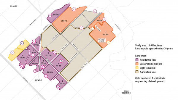
The Mildura East Growth Area (MEGA) Strategic Framework Vision and Key Directions report focuses on a massive 1,050 hectare area of land to the east of Mildura, between Irymple and Nichols Point, and how development will progress within the study area.
The report proposed a sequenced approach to development, dividing the land into three main components, a growth precinct to the south, which will continue the existing development of Irymple, a growth precinct to the north, which will build on the existing development of Nichols Point, and a non-urban area in between for agricultural use.
According to the report, backed by council on Thursday night, the two growth precincts together comprise a series of 15 development cells.
These cells, or parcels of land, could each accommodate between approximately 108 and 350 lots for development based on conservative estimates by the report’s authors.
Mildura Mayor Liam Wood said based on current trends, in conjunction with land available in Mildura South and elsewhere, this would be enough to cater for land development supply for the next three decades.
“We know based on existing building approval trends, the current five-year average for new dwellings in our municipality is 290 per year, and that’s taking in our entire municipality, including our outlying towns,” he said.
“The Mildura East Growth Area allows for a rate of 370 new dwellings per year, so it’s forecasting for development well ahead of the curve.”
The Mayor said an important consideration in the report was the need to ensure growth expanded from areas that already have existing infrastructure, such as drainage.
“This is an important and necessary consideration, rather than trying to establish costly infrastructure, like drainage, in isolated unconnected patches of the growth corridor,” he said.
“Unfortunately, this means that with an area this large, and with so many parcels of land, it’s impossible to meet every landowner’s expectations or future plans, particularly those who own farming land that isn’t close to existing development in the growth corridor.
“We understand their frustrations, but at the same time, the report outlines the need to follow this sequenced approach to ensure the best outcomes for our broader municipality. And while we acknowledge it may not suit every landowner’s immediate plans, the report does at least provide certainty to help with their future planning.”
Cr Wood said consultation with landowners and key stakeholders was an important step in development of the report.
“Feedback from this consultation was taken into account by the report’s authors, which is reflected in the document, including significant changes made based on information from Lower Murray Water,” he said.
“We look forward to continuing to work constructively with Lower Murray Water on any outstanding matters.”